In 1926 the United States created a legal precedent for zoning our cities, through the decision in the Euclid v. Ambler case. This was further reinforced with the publication of the final Standard State Zoning Enabling Act. Zoning, for better or worse became, and still is, the primary way we think about planning cities. The most important result of this is an environment in which we plan cities primarily by locating uses (even if those uses are mixed-uses).
But in 1928 the Department of Commerce published another Act, the Standard City Planning Enabling Act. In this simple and clear publication the DoC makes the case that any city should be laid out, first and foremost, through the projection of streets. It is essentially an act which enables cities to determine what is public (streets) and what is private (blocks), and that these things are carved out of a lot of land, regardless of its ownership or status.

In the 90 years since, the first publication has had far more impact on the physical landscape of the United States, and as a result, much of the rest of the world. The basis of the subdivision of land has been rendered subordinate to the idea of planning around the future use of a thing.
One terribly detrimental outcome of this shift in thinking has been the idea that things should be separated. And from this idea comes a single sentence that is embedded in almost every subdivision ordinance in every jurisdiction throughout the US, ‘Local streets shall be so laid out that their use by through traffic will be discouraged.’ This actually comes from the City of Atlanta’s 1957 Subdivision Ordinance. Embedded in this simple sentence is the idea that we shouldn’t be designing communities that are connected, and more specifically connected by streets.
Local streets shall be so laid out that their use by through traffic will be discouraged.
The diagram below shows us what the outcome of this simple, seemingly innocuous sentence (and one that is almost still universally supported in planning bureaus and neighborhoods alike).

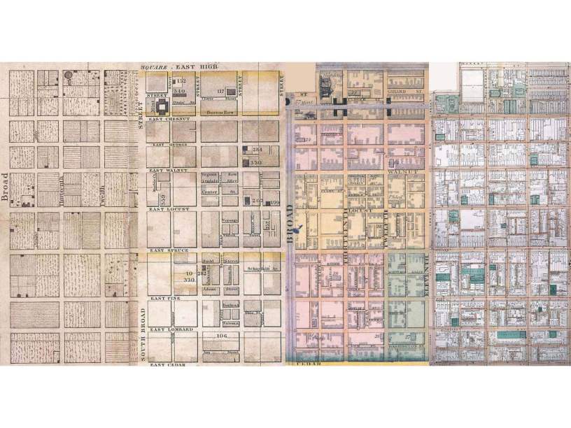
If we do this, however, it means we will never end up with anything like the great cities that were laid out and built prior to this transformation. If we think about a city like Philadelphia (see image below), the first thing done was laying out of streets, even though, as the first image clearly indicates, this was initially used as an area for agriculture. This series of plans of the city clearly shows how a system of streets can provide a simple way for cities to grow, and also, thankfully, a city where people can walk. In 1957, in Atlanta, not too many people were thinking about walking.

We now have subdivision ordinances that are incredibly complex, tied to comprehensive plans that are silent on the physical layout of cities (and scared to death to ever imagine telling people where future streets should be located), and driving cities to make places that are unwalkable, disconnected and completely unlike the original city of Philadelphia and its counterparts. In fact most subdivision regulations make it illegal to replicate Philadelphia, Manhattan, Savannah, Chicago or any other great city plan.
But there is a very simple solution. It may be hard to imagine, but a simple, two-sentence subdivision ordinance could actually result in much better places, much better cities.
“A block is a portion of privately owned land that is surrounded on all sides by public rights-of-way. No block perimeter shall exceed 1200 feet.”
That’s it.
What would the result of this be? Every new development or expansion of a city, or even a new city, would be connected and walkable. It might not be Savannah, ingenuous and beautiful, but it will never, by law, be the sprawling suburbs of the vast majority of 20th century (and unfortunately 21st century) America. In two simple sentences we could have a system that is incredibly clear, simple to understand, administer and build.
This won’t guarantee great cities but it will preclude horrible cities. With this ordinance you could build Philadelphia. The question we should be asking ourselves is why wouldn’t we do this.
Of course there are a million reasons why not, but every one of those reasons, without exception, results in less possibility for great cities.
One caveat, the number 1200 feet is not sacred. In this case it represents a block that is 240 feet x 360 feet, which works pretty well for both buildings and people walking. Each jurisdiction could, and would, change this to suit their needs (think Portland – 800 feet or Manhattan – 2000 feet, max, etc). The dimension should be the smallest number that accommodates the most varied set of building types. Remember the Empire State Building sits on a parcel of land that has a perimeter of about 1200 feet, and it’s a pretty big building.
Here’s a video/lecture on Subdivision: Subdivision-1

the word ‘grid’ can be misleading; I suggest that ‘network’ carries the essential meaning but need not imply orthogonal geometry. but regardless of topography, a dense network of streets and relatively small blocks is essential for good, walkable cities.
LikeLike
Yep. I have been struggling with this word for years. I recently landed on ‘web’. Now I just need to figure out how to describe it clearly. But you are absolutely right about the word grid.
LikeLike
Hello blogger, i must say you have high quality content here.
Your page should go viral. You need initial traffic only.
How to get it? Search for; Mertiso’s tips go viral
LikeLike
Cities with level land masses often work well with simple grids. High density thwarts workability by overpopulating sidewalks. In Atlanta Georgia only the immediate downtown districts utilize the grid yet the city fluorishes where streets follow hills and valleys. The notion that grids reign supreme is a myth.
LikeLike
Ansley Park is a grid. Grids don’t have to be orthagonal. Much of Olmsted’s work was based on a connected grid (Riverside) but not the NY gridiron.
LikeLike
Ansley Park isn’t a grid. It’s a meandering matrix with blocks not limited to an arbitrary 2400 linear foot rule. As it transitions to Peachtree Street it assumes a rigid orthogonal grid. The two sentence zoning clause has no place to hang its hat or shawl. Ansley was originally a suburb, distanced from downtown, accessed by the young automobiles.
LikeLike
loved reading this, addressing what seems a complex issue in simple two sentence
LikeLike